Category: Geography
Weekend Website #133: Embeddable Puzzles
It’s the time of year when children are looking for entertainment and parents want something fun to keep their cerebral fires burning. Entertainment-cerebra–that’s not an oxymoron. Check this website on States, and then check out the other topics available on Quiz Factor.
Share this:
- Click to share on Facebook (Opens in new window) Facebook
- Click to share on X (Opens in new window) X
- Click to share on LinkedIn (Opens in new window) LinkedIn
- Click to share on Pinterest (Opens in new window) Pinterest
- Click to share on Telegram (Opens in new window) Telegram
- Click to email a link to a friend (Opens in new window) Email
- More
Dear Otto: What About Carmen San Diego?
Dear Otto is an occasional column where I answer questions I get from readers about teaching tech. If you have a question, please complete the form below and I’ll answer it here. For your privacy, I use only first names.
Here’s a great question I got from Dawn:
We have upgraded our Computer Lab computers to Windows 7, some programs are now obsolete since they were DOS and will not run with 7. Carmen San Diego is one we used for Geography. Some teachers are sad we can’t use that anymore – the students did enjoy it. Do you know of anything our that can take its place? Thanks for your time!
I know what you mean. We tried to run it at my school–spent too much time tweaking everything–and never succeeded. I’ve had to toss it.
There are a few geography games you can look into:
- Geography games–National Geographic
- Geography—geonet game (from Houghton Mifflin)
- Geography Games II
They’re OK, but not as good as CSD. I’ll post your comment–see if anyone has any other ideas.
Share this:
- Click to share on Facebook (Opens in new window) Facebook
- Click to share on X (Opens in new window) X
- Click to share on LinkedIn (Opens in new window) LinkedIn
- Click to share on Pinterest (Opens in new window) Pinterest
- Click to share on Telegram (Opens in new window) Telegram
- Click to email a link to a friend (Opens in new window) Email
- More
Monday Freebies #40: Wonders of Google Earth
This year more than any before, classroom budgets have been cut making it more difficult than ever to equip the education of our children with quality teaching materials. I understand that. I teach K-8. Because of that, I’ve decided to give the lesson plans my publisher sells in the Technology Toolkit (110 Lesson Plans that I use in my classroom to integrate technology into core units of inquiry while insuring a fun, age-appropriate, developmentally-appropriate experience for students) for FREE. To be sure you don’t miss any of these:
…and start the week off with a fully-adaptable K-8 lesson that includes step-by-step directions as well as relevant ISTE national standards, tie-ins, extensions, troubleshooting and more. Eventually, you’ll get the entire Technology Toolkit book.
I love giving my material away for free. Thankfully, I have a publisher who supports that. If everyone did, we would reach true equity in international education.
Explore the Wonders of Google Earth
Students create their own tour on Google Earth using locations selected by the classroom teacher. They add the locations to Google Earth, add a fact about it and turn it into a tour.
Share this:
- Click to share on Facebook (Opens in new window) Facebook
- Click to share on X (Opens in new window) X
- Click to share on LinkedIn (Opens in new window) LinkedIn
- Click to share on Pinterest (Opens in new window) Pinterest
- Click to share on Telegram (Opens in new window) Telegram
- Click to email a link to a friend (Opens in new window) Email
- More
Tech Tip #65: Google Street View
As a working technology teacher, I get hundreds of questions from parents about their home computers, how to do stuff, how to solve problems. Each Tuesday, I’ll share one of those with you. They’re always brief and always focused. Enjoy!
Q: I can’t find enough detail about a particular area of the world that we’re studying in class. Any suggestions?
A: That’s a lot easier to do today than it used to be, thanks to Google Street View. Students love walking down the street that they just read about in a book or seeing their home on the internet. It’s also a valuable research tool for writing. What better way to add details to a setting than to go see it?
(more…)
Share this:
- Click to share on Facebook (Opens in new window) Facebook
- Click to share on X (Opens in new window) X
- Click to share on LinkedIn (Opens in new window) LinkedIn
- Click to share on Pinterest (Opens in new window) Pinterest
- Click to share on Telegram (Opens in new window) Telegram
- Click to email a link to a friend (Opens in new window) Email
- More
Weekend Website #68: Live Like Bear Grylls
Every Friday I’ll send you a wonderful website that my classes and my parents love. I think you’ll find they’ll be a favorite of your students as they are of mine.
Age:
3rd-5th
Topic:
Landforms
Review:
If you want to spice up a unit on landforms, have students look into surviving these unique natural habitats. To get out with their lives, they’ll have to understand the flora and fauna, dangers and helpers. Here are some websites they can visit to improve their survival toolkit:
Share this:
- Click to share on Facebook (Opens in new window) Facebook
- Click to share on X (Opens in new window) X
- Click to share on LinkedIn (Opens in new window) LinkedIn
- Click to share on Pinterest (Opens in new window) Pinterest
- Click to share on Telegram (Opens in new window) Telegram
- Click to email a link to a friend (Opens in new window) Email
- More
Weekend Website #67: 20 Websites to Learn Everything About Landforms
Every Friday I’ll send you a wonderful website that my classes and my parents love. I think you’ll find they’ll be a favorite of your students as they are of mine.
Age:
3rd grade
Topic:
Landforms
Review:
If your third grader has to write a report about landforms, try these websites (check here for updated list):
- About Rivers www.42explore.com/rivers.htm
- Biomes/Habitats http://www.allaboutnature.com/biomes/
- Deserts http://www.42explore.com/deserts.htm
- Explore the Colorado http://www.desertusa.com/colorado/explorriver/du_explorrv.html (more…)
Share this:
- Click to share on Facebook (Opens in new window) Facebook
- Click to share on X (Opens in new window) X
- Click to share on LinkedIn (Opens in new window) LinkedIn
- Click to share on Pinterest (Opens in new window) Pinterest
- Click to share on Telegram (Opens in new window) Telegram
- Click to email a link to a friend (Opens in new window) Email
- More
#39: Google Earth Board
Students select from a list of Wonders of the World (or locations put together in conjunction with the classroom teacher). They do brief research on it, locate it using Google Earth and make a short presentation to the class about it.
[gallery columns="2"]Jacqui Murray has been teaching K-18 technology for 30 years. She is the editor/author of over a hundred tech ed resources including a K-12 technology curriculum, K-8 keyboard curriculum, K-8 Digital Citizenship curriculum. She is an adjunct professor in tech ed, Master Teacher, webmaster for four blogs, an Amazon Vine Voice, CSTA presentation reviewer, freelance journalist on tech ed topics, contributor to NEA Today, and author of the tech thrillers, To Hunt a Sub and Twenty-four Days. You can find her resources at Structured Learning.
Share this:
- Click to share on Facebook (Opens in new window) Facebook
- Click to share on X (Opens in new window) X
- Click to share on LinkedIn (Opens in new window) LinkedIn
- Click to share on Pinterest (Opens in new window) Pinterest
- Click to share on Telegram (Opens in new window) Telegram
- Click to email a link to a friend (Opens in new window) Email
- More
20 Websites to Learn Everything About Landforms
If your third grader has to write a report about landforms, try these websites (check here for updates to list):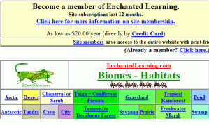
- About Rivers www.42explore.com/rivers.htm
- Biomes/Habitats http://www.allaboutnature.com/biomes/
- Deserts http://www.42explore.com/deserts.htm
- Explore the Colorado http://www.desertusa.com/colorado/explorriver/du_explorrv.html
- Geography Activities—for teachers www.enchantedlearning.com/geography/
- Geography Game—Geospy kids.nationalgeographic.com/Games/GeographyGames/Geospy

- Geography Quiz Game www.quia.com/pop/114591.html

- Geography Reading Problems www.tv411.org/lessons/cfm/reading.cfm?str=reading&num=8&act=4&que=1
- GeoNet Game www.eduplace.com/geonet/
- Labeling Maps www.iknowthat.com/com/L3?Area=LabelMaps
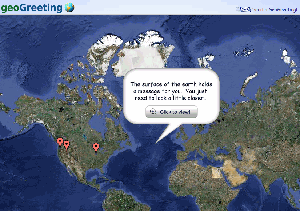
- Landforms make a greeting www.geogreeting.com/main.html
- Landforms www.edu.pe.ca/southernkings/landforms.htm
- Landforms—matching games, etc. www.quia.com/jg/29.html
- Los Angeles River Tour http://www.lalc.k12.ca.us/target/units/river/tour/index.html
- Map skills www.tv411.org/lessons/cfm/reading.cfm?str=reading&num=8&act=3&que=1
- Mapping Game www.sheppardsoftware.com/states_experiment_drag-drop_Intermed_State15s_500.html
- Rivers Seen from Space http://www.athenapub.com/rivers1.htm
- The Colorado River http://www.desertusa.com/gc/gcd/du_glencaydam.html
- What’s on a Map www.tv411.org/lessons/cfm/reading.cfm?str=reading&num=8&act=2&que=1
- Zambezi River Tour http://www.on-the-matrix.com/africa/zambezi.asp
Share this:
- Click to share on Facebook (Opens in new window) Facebook
- Click to share on X (Opens in new window) X
- Click to share on LinkedIn (Opens in new window) LinkedIn
- Click to share on Pinterest (Opens in new window) Pinterest
- Click to share on Telegram (Opens in new window) Telegram
- Click to email a link to a friend (Opens in new window) Email
- More
#40: Wonders of Google Earth
Students create their own tour on Google Earth using locations selected by the classroom teacher. They add the locations to Google Earth, add a fact about it and turn it into a tour.
[gallery columns="2" ids="44486,44485,44487,44484"]
Share this:
- Click to share on Facebook (Opens in new window) Facebook
- Click to share on X (Opens in new window) X
- Click to share on LinkedIn (Opens in new window) LinkedIn
- Click to share on Pinterest (Opens in new window) Pinterest
- Click to share on Telegram (Opens in new window) Telegram
- Click to email a link to a friend (Opens in new window) Email
- More
#45: How to Use MS Word to Teach Geography
Where Am I?
Use MS Word target diagram to organize the Universe. Start with the student’s town in the center and build out. Show students how to color the diagram. For olders, add a table at the bottom with the location and a fact about it. This is a great way to show kids how they can organize their thoughts with pictures, diagrams, tables—lots of ways other than simple text
[caption id="attachment_929" align="alignleft" width="182"]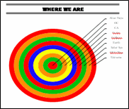 Sample diagram[/caption]
Grade Level: 3-5
Background: Using MS Word.
Vocabulary: diagram, graphic organizer, solar system
Time: About 30 minutes
Steps:
- Open MS Word. Add a heading to the top.
- Add a title–Where We Are–centered, bold and font 14. Use this to point out the toolbar with the four alignment tools, bold, fonts and font size (more…)
Share this:
- Click to share on Facebook (Opens in new window) Facebook
- Click to share on X (Opens in new window) X
- Click to share on LinkedIn (Opens in new window) LinkedIn
- Click to share on Pinterest (Opens in new window) Pinterest
- Click to share on Telegram (Opens in new window) Telegram
- Click to email a link to a friend (Opens in new window) Email
- More


